 Closest Hiking Trails Near Pocatalico, West Virginia, United States
- World Trails
- All Trails
- Country
- United States
- State
- West Virginia
- City
- Pocatalico
- Can't find your trail?
- Add it to the database
-
1. Kanawha Trace
Hiking trail from the Guyandotte river to the Kanawha River (Barboursville to Fraziers Bottom) 3 shelters available for use along the way
Distance: 32.0 miles
Barboursville, West Virginia, United States

-
2. Hawks Nest Dam
An easy hike down a road (most the way) past many "fishing trails" to the lower side of the Hawks Nest Dam.
Distance: 2.0 miles
Ansted, West Virginia, United States
-

3. Long Point Trail - New River Gorge Bridge View
A relatively easy hike to the best view of the famous New River Bridge, Fayetteville, WV.
Distance: 3.1 miles
Fayetteville, West Virginia, United States
-

4. New River Gorge Scenic Overlooks
A trail to 4-5 scenic overlooks, rock climbing, and rapelling spots on the New River Gorge.
Distance: 1.0 miles
Fayetteville, West Virginia, United States
-
5. Summersville Lake NE Trails
A popular trailhead for rock climbers in Summersville. Also provides some nice woods trails.
Distance: 1.0 miles
Summersville, West Virginia, United States
-
6. Rock House Trail
This trail accesses rock overhangs and follows a cliff face
Distance: 0.8 miles
Ironton, Ohio, United States
-

7. New River Gorge National River - Grandview Main Overlook
The view from the Main Overlook includes seven miles of the New River.
Distance: 0.1 miles
Beckley, West Virginia, United States
-
8. Cass West Virginia
Distance: 3.0 miles
Cass, West Virginia, United States
-

9. New River Gorge National River - Sandstone Falls
Large waterfall across the new River Gorge
Distance: 0.5 miles
Lewisburg, West Virginia, United States
-
10. Kinderhook Trail
This trail winds through some of the steeper hills on the Wayne National Forest
Distance: 12.0 miles
Newport, Ohio, United States
-

11. Falls of Hills Creek
A short hike to 3 waterfalls (gets better as you go)
Distance: 1.5 miles
Richwood, West Virginia, United States
-
12. Canyon Rim Trail to Heritage Point
Distance: 1.4 miles
Lerona, WV, West Virginia, United States
-
13. Lick Hollow Trail
Day Hike Loop
Distance: 1.6 miles
Lerona, WV, West Virginia, United States
-
14. Wildcat Hollow Hiking Trail
The trail will lead through tall pine forests, open meadows, quiet streams, rock outcroppings, and down old roads overlooking miles of beautiful landscape
Distance: 5.0 miles
Columbus, Ohio, United States
-
15. Lamping Homestead
Today the area offers camping and picnicking, fishing, canoeing, and a scenic hiking trail
Distance: 5.0 miles
Marietta, Ohio, United States
-

16. Rice Fields
Follow the Appalachian Trail to a bald offering sweeping westward views
Distance: 6.0 miles
Pearisburg, Virginia, United States
-

17. Rice Fields - New Route
Rice Fields - New
Distance: 14.2 miles
Pearisburg, Virginia, United States
-
18. Angel's Rest
Short hike to an overlook on the Appalachian Trail
Distance: 4.6 miles
Pearisburg, Virginia, United States
-
19. Cass Scenic Railroad
Nostalgic train ride to Bald Knob
Distance: 0.1 miles
Cass, West Virginia, United States
-
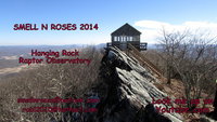
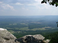
20. Hanging Rock Tower
Wooden tower on ridge top provides stunning 360 degree panoramic views
Distance: 1.8 miles
Waiteville, West Virginia, United States
-
21. The Sheltowee Trace
Ky's Long Trail Runs the Length of Daniel Boone Forest and Big South Fork Rec. Area
Distance: 282.0 miles
Morehead, Kentucky, United States
-
22. Wind Rock
A quick, easy hike up to a nice overlook.
Distance: 0.5 miles
Blacksburg, Virginia, United States
-
23. Cascades And Barney's Wall
Easy hike to a large waterfall
Distance: 4.0 miles
Pembroke, Virginia, United States
-
24. Lake Moomaw - Greenwood Point Trail
Nice hike to an overlook of the lake
Distance: 6.4 miles
Warm Springs, Virginia, United States
-
25. Dismal Creek and Sugar Run Mountain
Loop hike to the top of Sugar Run Mountain and waterfall at the trailhead
Distance: 9.6 miles
Pearisburg, Virginia, United States