 Closest Hiking Trails Near Chatmoss, Virginia, United States
- World Trails
- All Trails
- Country
- United States
- State
- Virginia
- City
- Chatmoss
- Can't find your trail?
- Add it to the database
-
1. Fairy Stone State Park
The largest of Virginia's six original state parks, is home to its namesake "fairy stones."
Distance: 9.0 miles
Stuart, Virginia, United States

-
2. Waid Recreation Park
7 Miles of Walking & Hiking Trails
Distance: 7.0 miles
Rocky Mount, Virginia, United States
-
3. Smart View Loop
Nice short loop hike to multiple views
Distance: 3.0 miles
Floyd, Virginia, United States
-
4. Chantilly Trail
Chantilly Trail is one of the many trails on the Chantilly Farm trail system that traverse the 200-acre farm located in the Blue Ridge Mountains. .
Distance: 0.5 miles
Roanoke, Virginia, United States
-
5. Hanging Rock State Park
Enjoy beautiful mountain and river views
Distance: 9.5 miles
Danbury, North Carolina, United States
-
6. Rock Castle Gorge Trail
Hike from the ridge line down to creeks and back
Distance: 10.8 miles
Floyd, Virginia, United States
-
7. Buffalo Mountain Natural Area Preserve
On the treeless summit, strong winds and boreal climate support subalpine vegetation including three-toothed cinquefoil and Rocky Mountain woodsia
Distance: 2.0 miles
Floyd, Virginia, United States
-
8. Bottom Creek Gorge / Bent Mountain Falls
Forming the headwaters of the Roanoke River, Bottom Creek Gorge boasts spectacular scenery
Distance: 5.0 miles
Roanoke, Virginia, United States
-
9. Stiles Falls
60 foot waterfall
Distance: 3.0 miles
Shawsville, Virginia, United States
-
10. Chestnut Ridge Trail
Easy but scenic trail along the Blue Ridge Parkway
Distance: 5.3 miles
Roanoke, Virginia, United States
-
11. Happy Hollow Trails
Roanoke County's Happy Hollow Gardens features a beautiful hike through a wooded landscape.
Distance: 2.0 miles
Roanoke, Virginia, United States
-
12. Mill Mountain Star Trail
Hike to the top of Mill Mountain to see the Roanoke Star
Distance: 3.4 miles
Roanoke, Virginia, United States
-
13. Pilot Mountain
Hike up to the base of this mountain
Distance: 5.0 miles
Pinnacle, North Carolina, United States
-
14. Hanging Rock Battlefield Trail
The nearly two-mile path follows the route of an abandoned railroad, donated by Norfolk and Southern
Distance: 3.4 miles
Salem, Virginia, United States
-
15. Falls Ridge Natural Preserve
Part of a steep, rugged ridge that rises from the valley of the North Fork of the Roanoke River
Distance: 5.0 miles
Ironto, Virginia, United States
-
16. Read Mountain to Buzzard Rocks
The view from the top is one of the best in the Roanoke Valley
Distance: 3.8 miles
Roanoke, Virginia, United States
-
17. Carvin Cove / Hay Rock Overlook
Follow the Appalachian Trail to views of the Carvin Cove reservoir at the Hay Rock overlook
Distance: 8.0 miles
Roanoke, Virginia, United States
-
18. Carvins Cove to McAfee Knob
21 Miles from Carvins Cove starting at US220 to McAfee Knob Parking Lot at VA 311
Distance: 21.0 miles
Salem, Virginia, United States
-
19. Huckleberry Trail
Nice paved trail between Blacksburg and the mall
Distance: 11.4 miles
Blacksburg, Virginia, United States
-
20. Hi-Dee-Hoe
Hike to top of Brushy Mountian
Distance: 3.0 miles
Roanoke, Virginia, United States
-
21. Fullhardt Knob
Troutville (Rt. 11) to Fullhart Knob Shelter
Distance: 7.8 miles
Troutville, Virginia, United States
-
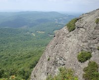
22. McAfee's Knob
Popular hike to a beautiful view and impressive rock formation
Distance: 7.0 miles
Roanoke, Virginia, United States
-
23. Sawtooth Ridge Overlooks
Both overlooks sit atop rock outcroppings and provide nice views of Bradshaw Valley and Fort Lewis Mtn
Distance: 2.0 miles
Catawba, Virginia, United States
-
24. North Mountain (aka The Dragon's Spine)
A strenuous ridgeline hike on an old section of the Appalachian Trail
Distance: 12.0 miles
Roanoke, Virginia, United States
-
25. Dragon's Tooth
Hike the Appalachian Trail to this famous rock outcrop.
Distance: 4.6 miles
Roanoke, Virginia, United States