 Closest Hiking Trails Near Fort Mitchell, Virginia, United States
- World Trails
- All Trails
- Country
- United States
- State
- Virginia
- City
- Fort Mitchell
- Can't find your trail?
- Add it to the database
-
1. Appomattox State Forest - Carter Taylor Trail
Wildlife abounds in the ever-changing oak-hickory and pine forest. Deer, turkey, and even black bear make their homes in these woods.
Distance: 12.0 miles
Appomattox, Virginia, United States

-
2. James River Heritage Trail
This is a beautiful scenic walk or bike ride through an historical area
Distance: 5.0 miles
Lynchburg, Virginia, United States
-
3. Five Forks Trails
A series of easy to moderate trails in Dinwiddie County, Virginia, designed for hiking/equestrian.
Distance: 8.5 miles
Dinwiddie, Virginia, United States
-
4. James River State Park
The park has three miles of river frontage, 1,500 acres of rolling farm meadows, three fishing ponds, beautiful vistas, 15 miles of hiking trails and quiet forests
Distance: 15.0 miles
Lynchburg, Virginia, United States
-
5. Virginia Blue Ridge Railway Trail
This trail is idyllically located in the rolling Virginia countryside and follows the banks of the Piney and Tye Rivers
Distance: 8.0 miles
Piney River, Virginia, United States
-
6. Otter Lake Loop Trail
Provides scenic views of Otter Lake
Distance: 0.9 miles
Glasgow, Virginia, United States
-
7. Eno River State Park - Cox Mountain Trail
3.75 mile loop around Cox Mountain
Distance: 3.8 miles
Hillsborough, North Carolina, United States
-
8. Otter Creek Trail
Parallels the Blue Ridge Parkway from Otter Campground to the James River Visitor Center
Distance: 3.5 miles
Glasgow, Virginia, United States
-
9. Canal Lock Trail
Leads to the restored Battery Creek Lock on the James River
Distance: 0.4 miles
Glasgow, Virginia, United States
-
10. Trail Of Trees
The trails wanders through a shaded stream drainage
Distance: 0.4 miles
Glasgow, Virginia, United States
-
11. Petersburg Battlefield Battery Trail
Short Hike from the Petersburg Eastern Front Visitor Center
Distance: 0.5 miles
Petersburg, Virginia, United States
-
12. Little and Big Rocky Row Hike
This streneous hike takes you to the summit of Big Rocky Row with views into the James River Valley
Distance: 8.0 miles
Glasgow, Virginia, United States
-
13. Big Rocky Row Loop
AT to Big Rocky and returning on Saddle Gap trail
Distance: 9.3 miles
Glasgow, Virginia, United States
-
14. Occoneechee Mountain Trail
Very Nice Intermediate Trail the highest point in Orange County.
Distance: 2.0 miles
Hillsborough, North Carolina, United States
-
15. Highcock Knob / Sulphur Spring Trail Loop
Loop hike through the James River Wilderness with a few overlooks
Distance: 8.1 miles
Big island, Virginia, United States
-
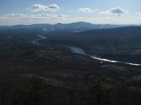
16. Mount Pleasant
Relaxing hike to the summit with two rock outcrops offering beautiful views
Distance: 6.0 miles
Buena Vista, Virginia, United States
-
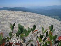
17. Cold Mountain Loop
Cold Mountain is a bald affording nice, open views
Distance: 5.7 miles
Buena Vista, Virginia, United States
-
18. Apple Orchard Mountain Summit
Distance: 1.8 miles
Buchanan, Virginia, United States
-
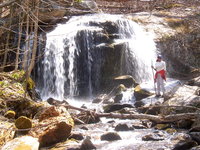
19. The Priest to Crabtree Falls
Hike the toughest part of the Appalachian Trail and descend next to a large cascading waterfall
Distance: 8.6 miles
Montebello, Virginia, United States
-
20. Bluff Mountain
Short and steep hike along the Appalachian Trail to a nice view.
Distance: 4.0 miles
Amherst, Virginia, United States
-
21. The Priest
Hike the toughest part of the Appalachian Trail
Distance: 8.0 miles
Montebello, Virginia, United States
-
22. Apple Orchard Falls (Blue Ridge Parkway Trailhead)
Loop hike to a 150 foot waterfall from the Blue Ridge Parkway
Distance: 7.5 miles
Buchanan, Virginia, United States
-
23. Little Rocky Row / Fullers Rocks
Lesser used trail, ending with the rocks that sit atop the ridge and afford an outstanding, unobstructed view north, east, and south
Distance: 6.0 miles
Glasgow, Virginia, United States
-
24. Flat Top
Spectacular Blue Ridge Mountain views
Distance: 5.8 miles
Buchanan, Virginia, United States
-
25. Devil's Marbleyard
Loop hike around this boulder field
Distance: 8.5 miles
Natural Bridge Station, Virginia, United States