 Closest Hiking Trails Near Jerryville, West Virginia, United States
- World Trails
- All Trails
- Country
- United States
- State
- West Virginia
- City
- Jerryville
- Can't find your trail?
- Add it to the database
-
1. Cass West Virginia
Distance: 3.0 miles
Cass, West Virginia, United States

-
2. Falls of Hills Creek
A short hike to 3 waterfalls (gets better as you go)
Distance: 1.5 miles
Richwood, West Virginia, United States
-
3. Cass Scenic Railroad
Nostalgic train ride to Bald Knob
Distance: 0.1 miles
Cass, West Virginia, United States
-
4. Summersville Lake NE Trails
A popular trailhead for rock climbers in Summersville. Also provides some nice woods trails.
Distance: 1.0 miles
Summersville, West Virginia, United States
-
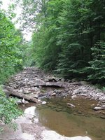
5. Back Creek Gorge Trail
Back Creek is a stocked trout stream, with several deep pools that are inviting for fishing and swimming
Distance: 1.0 miles
Warm Springs, Virginia, United States
-
6. Lake Moomaw - Greenwood Point Trail
Nice hike to an overlook of the lake
Distance: 6.4 miles
Warm Springs, Virginia, United States
-
7. Laurel Fork Trails
Laurel Fork is in the headwaters of the Potomac River in the Allegheny Mountains with elevations to 4,000'
Distance: 1.0 miles
Hightown, Virginia, United States
-
8. Bear Rock Trail
This trail leads you through hardwood forest and rock outcroppings to the top of Warm Springs Mountain
Distance: 1.0 miles
Warm Springs, Virginia, United States
-
9. Douthat State Park - Tuscarora Overlook
Long loop hike to the park's main overlook
Distance: 9.7 miles
Clifton Forge, Virginia, United States
-
10. Beards Mountain Spur Trail
Beautiful views of the surrounding mountains.
Distance: 1.0 miles
Warm Springs, Virginia, United States
-
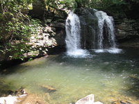
11. Seneca Creek and Falls
Beautiful stream hike to a nice waterfall with a swimming hole
Distance: 10.0 miles
Elkins, West Virginia, United States
-
12. McDowell Battlefield Trail
The McDowell Battlefield Trail leads to the top of Sittlington Hill and the core of the McDowell Battlefield
Distance: 1.0 miles
McDowell, Virginia, United States
-
13. Dry Run Trail
Great views of Big Knob and Bald Knob, two of the highest points in the Allegheny Mountains.
Distance: 9.0 miles
Covington, Virginia, United States
-

14. New River Gorge Scenic Overlooks
A trail to 4-5 scenic overlooks, rock climbing, and rapelling spots on the New River Gorge.
Distance: 1.0 miles
Fayetteville, West Virginia, United States
-

15. Long Point Trail - New River Gorge Bridge View
A relatively easy hike to the best view of the famous New River Bridge, Fayetteville, WV.
Distance: 3.1 miles
Fayetteville, West Virginia, United States
-
16. Shenandoah Mountain Trail
The trail is a remote, backcountry trail which winds through the ridges of the Shenandoah Mountain Range.
Distance: 23.7 miles
Staunton, Virginia, United States
-
17. Hawks Nest Dam
An easy hike down a road (most the way) past many "fishing trails" to the lower side of the Hawks Nest Dam.
Distance: 2.0 miles
Ansted, West Virginia, United States
-
18. Ramsey's Draft Wilderness - West Loop
Ramsey's Draft and Shenandoah Mountain Trail Loop
Distance: 16.7 miles
Staunton, Virginia, United States
-
19. Ramsey's Draft Wilderness - East Loop
Loop backpack in Ramsey's Draft Wilderness
Distance: 16.2 miles
Staunton, Virginia, United States
-
20. Rich Hole Wilderness Trail
The trail offers a great opportunity to the hiker in search of solitude, wildlife, and spectacular views of the surrounding mountains and valleys
Distance: 5.5 miles
Clifton Forge, Virginia, United States
-
21. Children's Forest Trail
The Children’s Forest trail is an all weather surface loop trail that begins and ends in the monument area of the National Children’s Forest
Distance: 0.3 miles
Covington, Virginia, United States
-
22. Roaring Run Trail
Cascading stream and scenic waterfalls
Distance: 1.5 miles
Eagle Rock, Virginia, United States
-
23. Blue Suck Run Trail
Blue Suck Run Trail is a moderately difficult hike with many easy stream crossings.
Distance: 3.4 miles
Longdale, Virginia, United States
-
24. Cold Springs Trail
The trail passes through a diversity of terrain and several overlooks and offers excellent views of the Deerfield Valley.
Distance: 4.4 miles
Staunton, Virginia, United States
-
25. Cocks Comb Trail
This trail has the most spectacular viewing opportunity on the district
Distance: 0.5 miles
Longdale, Virginia, United States