 Closest Hiking Trails Near Snelling, California, United States
- World Trails
- All Trails
- Country
- United States
- State
- California
- City
- Snelling
- Can't find your trail?
- Add it to the database
-
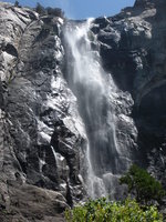
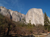
1. Yosemite National Park - Bridal Veil Fall
Short hike to a waterfall
Distance: 0.5 miles
Yosemite National Park, California, United States

-
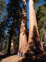
2. Yosemite National Park - Mariposa Grove of Giant Sequoias
Hike to large Giant Sequoias
Distance: 4.0 miles
Yosemite National Park, California, United States
-
3. Yosemite National Park - Four Mile Trail
Climb to the top of Yosemite Valley at Glacier Point
Distance: 9.6 miles
Yosemite National Park, California, United States
-
4. Yosemite National Park - Upper Yosemite Fall
The Yosemite Falls Trail leads to the top of North America’s tallest waterfall
Distance: 7.2 miles
Yosemite National Park, California, United States
-
5. Yosemite National Park - Lower Yosemite Fall
This short, easy walk rewards with spectacular views of Upper and Lower Yosemite Fall
Distance: 1.1 miles
Yosemite National Park, California, United States
-
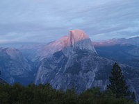
6. Yosemite National Park - Cook's Meadow Loop
This short, easy walk offers stunning views of Half Dome, Glacier Point, and Royal Arches
Distance: 1.0 miles
Yosemite National Park, California, United States
-
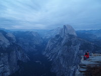
7. Yosemite National Park - Panorama Trail
This trail offers some incredible panoramic views of Yosemite Valley
Distance: 8.5 miles
Yosemite National Park, California, United States
-
8. Yosemite National Park - Mirror Lake/Meadow
Hike to a lake
Distance: 5.0 miles
Yosemite National Park, California, United States
-
9. Yosemite National Park - Valley Floor Loop
This trail follows many of the Valley's first east-west trails and wagon raods
Distance: 13.0 miles
Yosemite National Park, California, United States
-
10. Yosemite National Park - Half Dome
Hike to the top of Half Dome
Distance: 17.0 miles
Yosemite National Park, California, United States
-
11. Yosemite National Park - Vernal & Nevada Falls
Hike to the top of two waterfalls
Distance: 7.0 miles
Yosemite National Park, California, United States
-
12. Heritage Oak Trail
A beautiful trail the winds through vineyards and oak trees, and then along the Mokelumne River.
Distance: 2.5 miles
Acampo, California, United States
-
13. Lake Tahoe - Echo Lakes Trailhead
Hike to many lakes
Distance: 5.0 miles
South Lake Tahoe, California, United States
-
14. Devil's Postpile and Rainbow Falls
Short hike to geologic wonder which continues on to a beautiful waterfall
Distance: 2.5 miles
Mammoth Lakes, California, United States
-
15. Leona Canyon Regional Open Space Preserve
A pristine wooded canyon is protected in this 290-acre parkland near Merritt College in Oakland.
Distance: 5.0 miles
Oakland, California, United States
-
16. Redwood Regional Park Trail Network
Hidden redwood forest whose peaceful groves give little evidence of its bustling past
Distance: 3.7 miles
Oakland, California, United States
-
17. Lake Tahoe - Angora Lakes
Traversing through loose shale up a steep grade, the trail ends at Angora Lakes
Distance: 1.0 miles
South Lake Tahoe, California, United States
-
18. Lake Tahoe - Glen Alpine Trailhead
Hike to manyu lakes and waterfalls
Distance: 10.0 miles
South Lake Tahoe, California, United States
-
19. Franklin Ridge Trail - Carquinez Strait Regional Shoreline
Carquinez Strait Regional Shoreline comprises 1,415 acres of bluffs and shoreline along Carquinez Scenic Drive between the town of Crockett and the hillsides overlooking Martinez.
Distance: 2.4 miles
Martinez, California, United States
-
20. Lake Tahoe - Moraine Trail
Stroll along a relatively flat trail through the forest and along the shore of picturesque Fallen Leaf Lake
Distance: 2.0 miles
South Lake Tahoe, California, United States
-
21. Lake Tahoe - Mount Tallac
Spectacular view of Fallen Leaf Lake, Lake Tahoe, and Desolation Wilderness
Distance: 10.0 miles
South Lake Tahoe, California, United States