 TrailHeadFinder.com - World Campgrounds
- Countries
 United States6955
- Displaying Campground 51 - 75 of 6955 in total
-
Alder Creek Campground
Elevation: 238 ft
Carpinteria, California, United States
-
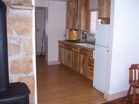
Alder Guard Station Cabin
The Alder Guard Station is located two miles north of the town of South Fork along Alder Creek. The guard station was built in 1910 and was the residence and office for the local ranger district. The guard station is ideally situated to access trails and roads in the area to explore the Divide Ranger District. The kitchen and bathroom have been renovated. There is electricity, hot water, indoor toilet, electric stove,refridgerator, dining room table, kitchen table, two bunkbeds, one single bed (with mattresses) on the second floor and a couch on the first floor. Some kitchen utensils and pots and pans are provided. Bring sleeping bags and/or blankets/sheets. There is a wood stove in the guard station (wood and splitting maul provided) and several picnic tables outside. The wood stove is the only source of heat for the guard station. The area offers many opportunities for hiking, horseback riding, 4 wheel drive adventures, hunting, wildlife viewing, boating, fishing, etc. The trailhead for the Alder Bench Trail is located just north of the guard station. Forest Road 610 is a 4x4 gravel road north of the guard station. Renters are required to pack out all garbage. DO NOT BURN GARBAGE IN THE FIRE PIT OR WOOD STOVE. PACK IT IN, PACK IT OUT. CABIN MUST BE CLEANED BEFORE LEAVING. LEAVE THE CABIN IN THE CONDITION YOU WOULD LIKE TO FIND IT. Visitors to the National Forest are responsible for knowing the rules and regulations of the forest. Contact the Rio Grande National Forest for more information: http://www.fs.fed.us/r2/riogrande/ or call 719-657-3321 or 719-852-5941. (Monday - Friday only).
Elevation: ft
South Fork, Colorado, United States
-
Alder Lake Campground
Elevation: 118 ft
Alder, Washington, United States
-
Alder Thicket Campground
Elevation: 475 ft
Pataha, Washington, United States
-
Alderwood Campground
Elevation: 483 ft
Gisela, Arizona, United States
-
Alejandro Campground
Elevation: 152 ft
Garey, California, United States
-
Alejandro Campground
Elevation: 151 ft
Garey, California, United States
-
Aliso Campground
Elevation: 266 ft
Taft Heights, California, United States
-
All Seasons Campground
Elevation: 82 ft
Weare, New Hampshire, United States
-
All Seasons Recreational Vehicle Park and Campground
Elevation: 37 ft
Hidden Meadows, California, United States
-
Allen Pond Campground
Elevation: 34 ft
Greene, Maine, United States
-
Alley Spring Campground
Elevation: 63 ft
Eminence, Missouri, United States
-
Allie Cove Campground
Elevation: 109 ft
Shasta Lake, California, United States
-
Allison Creek Campground
Elevation: 172 ft
Riggins, Idaho, United States
-
Almanor Campground
Elevation: 424 ft
Chester, California, United States
-
Almont Campground
Almont Campground is located adjacent to Colorado State Highway 135. It is typically used for short-term stays of 1 to 5 days. This campground is in walking distance of the Almont Gorge, where the East River and Taylor River join to form the Gunnison River. Other recreation opportunities from Almont Campground include 4-wheel driving, mountain biking and kayaking. The landscape is mostly aspen and cottonwood trees. There are 10 campsites.
Elevation: 8000 ft
Almont, Colorado, United States
-
Alms Campground
Elevation: 165 ft
Lockwood, California, United States
-
Alms Campground
Elevation: 157 ft
Lockwood, California, United States
-
Alphine Campground
Elevation: 276 ft
Monitor, Washington, United States
-
Alpine Campground
Elevation: 604 ft
South Lake Tahoe, California, United States
-
Alpine Campground
Elevation: 526 ft
Alpine, Wyoming, United States
-
Alpine Campground
Elevation: 525 ft
Alpine, Wyoming, United States
-
Alpine Campground
Elevation: 526 ft
Alpine, Wyoming, United States
-
Alpine Campground
Elevation: 525 ft
Alpine, Wyoming, United States
-
Alpine Divide Campground
Elevation: 785 ft
Alpine, Arizona, United States